| |
 |
|
 |
|
|
|
|
|
|
|
|
|
|
|
|
|
|
|
|
|
|
|
|
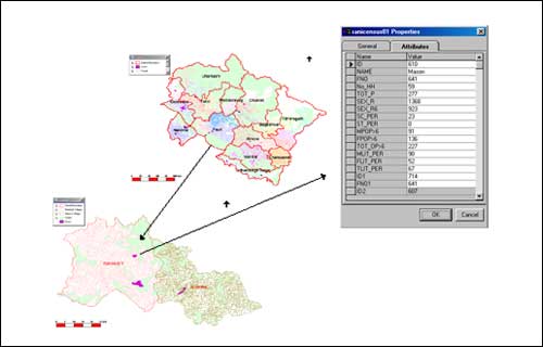
Village Information System (2002 onward): People's Science Institute has developed a revolutionary software application, Village Information System (VIS), for knowledge- based decision-making. It can provide detailed data on every Indian village, district and state. It is a user-friendly Geographical Information System (GIS) application that can display data from the 1991 and 2001 Census of India in the form of maps, tables and graphs to present information thematically. Other databases like the National Education Survey, National Health Survey, National Agriculture Survey, National Handloom Survey, etc. are also being linked to the system. A demonstration model has been developed for the state of Uttarakhand. |
|
|
|
|
|
|
|
|
|
|
|
|
|
|
|
|
PSI's VIS is specifically useful for planners, policy-makers, administrators and researchers. It can display geo-referenced maps of any political boundary from the state to the village level. Accurate Census data covering about 200 parameters related to social welfare (including demography), infrastructure and natural resources are attached for each unit. The system allows analysis of all these parameters and their trends at the village, district, state and national levels. It can prepare thematic maps in response to user's queries presented in normal language. This allows for a rapid and visual grasp of the implications in terms of spatial variations. Such thematic maps are effective tools for development programmes/projects planning. |
|
|
| |
 |
| |
|
|
|
|
|
|
They help in making sound decisions that will have a lasting and positive impact on people's lives.
The system helps decision-makers to study the current situation, to set precise goals for future action and monitor progress with respect to the desired goals.
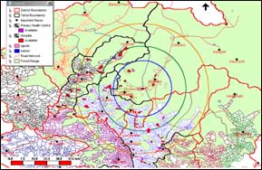
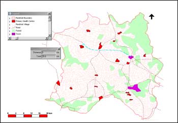
It is specifically useful for disaster response and management. It enables district administrators to immediately identify the worst affected areas, access roads and infrastructure available - schools for shelter, primary health centers, etc - in the nearby less-affected areas. Census data for the affected villages give details of the size and nature of the affected population as well as the infrastructure at risk. VIS can also be integrated with remote sensing applications for detailed and quick analysis of disaster-affected areas.
Users, including individuals, organizations and government agencies can obtain specific data, determine trends between 1991 and 2001 and generate their own thematic maps. For example, in the field of health, persons can easily access or compile Census data for any number of villages on juvenile and adult sex ratios, literacy levels, health services, water and sanitation, incidence of diseases, etc. Correlations between them can also be easily made. |
|
|
|
|
|
|
|
|
|
Putting it in the public domain, i.e., by making it web-accessible can vastly enhance the utility of the system. This, however, requires the installation of a server system. Recently the Department of Science and Technology, GoI has approved a project to install a server system and upload VIS for Uttaranchal in the web. Once this is done, users can not only download the available data and organize it to suit their specific requirements, but they can also link their own databases to the system. All that they require is a computer with an Internet connection.
Over a three year time-frame, PSI would like to develop its VIS for the entire country covering all the states, districts, tehsils and villages. |
|
|
|
|
|
|
|
|
|
|
|
|
|
|